
Key Takeaways
- A Geocoding API converts addresses into latitude and longitude, but enterprise reliability depends on parsing, validation, confidence scoring, and precision metadata.
- Address geocoding should distinguish rooftop, parcel, street-level, interpolated, postal-code, and city-level results.
- A reverse geocoding API converts coordinates back into usable place, address, boundary, or area context.
- Batch geocoding helps enterprises process large address files for analytics, CRM enrichment, site selection, territory planning, and location intelligence.
- Geocoding quality controls prevent poor addresses from becoming misleading maps, trade areas, routes, or location models.
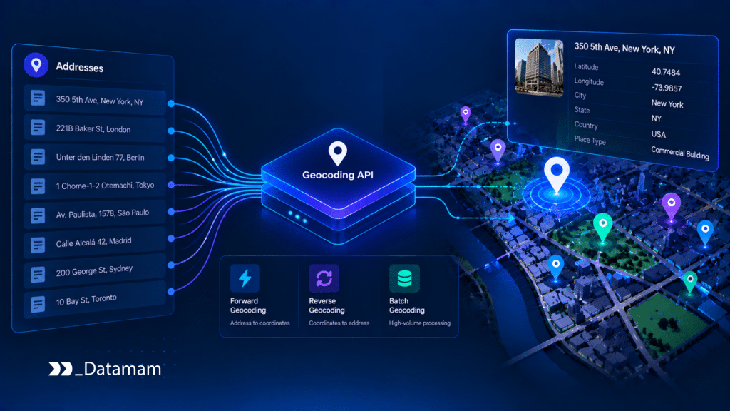
A Geocoding API turns written addresses into usable coordinates. That conversion looks simple from the outside: submit an address, receive latitude and longitude. In enterprise systems, however, geocoding is a control layer that determines whether address data can be trusted in analytics, mapping, territory planning, routing, POI matching, and site selection.
Address geocoding fails when the input is incomplete, ambiguous, misspelled, outdated, duplicated, or formatted for a different country. A coordinate may still be returned, but it may represent a rooftop, street segment, postal-code centroid, or approximate city point.
Therefore, the question is not only whether a Geocoding API returns coordinates. The question is whether it returns usable location data with confidence, precision, and governance context.
Why Geocoding Quality Matters
Geocoding quality matters because every downstream location decision depends on the placement of the address. A small coordinate error can move a business into the wrong trade area, delivery zone, sales territory, catchment, census area, or competitor cluster.
Deloitte’s geospatial analytics research describes geospatial use cases across site selection, supply chains, risk, public services, and operations. These workflows depend on reliable spatial data because inaccurate coordinates weaken the analysis layer before decision-making begins.
Address Text Is Not Location Data Yet
An address is a text representation of a place. It may include abbreviations, missing unit numbers, informal building names, old street names, local spelling differences, or incomplete postal information.
Before geocoding, the address must be parsed and standardized. Street, city, region, postal code, country, unit, building, and formatted address should be separated where possible.
Without this step, the API may match the wrong location or return a low-precision result that looks usable but is not safe for enterprise workflows.
Coordinates Need Precision Context
Latitude and longitude are not enough. Enterprise teams need to know what the coordinate represents.
A rooftop coordinate is different from a parcel point. A street-level match is different from an interpolated segment. A postal-code centroid is different from a verified business entrance. A city centroid should not be used for site selection or delivery planning.
A Geocoding API should return precision type, match confidence, and quality status so downstream systems can accept, reject, or review the result.
How Address Geocoding Works
Address geocoding turns an input address into coordinates through matching, standardization, scoring, and output formatting.
The process should expose enough metadata for enterprise teams to understand the result.
Parsing and Normalization
Parsing separates the address into components. Normalization standardizes abbreviations, casing, postal formats, country names, street types, and administrative regions.
For example, “St.” may become “Street,” “NY” may become “New York,” and a country name may be standardized into an ISO format. International address handling is more complex because formats differ by country and language.
A strong geocoding workflow should preserve both raw input and normalized output. This allows teams to audit what changed during processing.
Match Scoring and Candidate Selection
A Geocoding API may find several possible candidates for one address. The system should score candidates by address similarity, postal match, administrative boundary, known place data, coordinate precision, and source confidence.
Ambiguous addresses should not be forced into production silently. If an address could refer to multiple locations, the result should be flagged for review or enriched with additional context.
A simple geocoding validation pattern can look like this:
GEOCODING_RULES = {

    "minimum_confidence": 0.85,

    "allowed_precision": ["rooftop", "parcel", "street_address"],

    "blocked_precision": ["postal_code", "city_centroid", "unknown"],

}


def approve_geocode_result(result):

    if result.get("confidence", 0) < GEOCODING_RULES["minimum_confidence"]:

        return {"approved": False, "reason": "low_geocode_confidence"}


    if result.get("precision") in GEOCODING_RULES["blocked_precision"]:

        return {"approved": False, "reason": "insufficient_precision"}


    if result.get("precision") not in GEOCODING_RULES["allowed_precision"]:

        return {"approved": False, "reason": "unsupported_precision"}


    return {"approved": True}
This prevents weak geocoding results from entering site selection models, trade area analysis, routing systems, or POI matching workflows.
Reverse Geocoding API Workflows
A reverse geocoding API converts coordinates back into address, place, neighborhood, city, postal code, administrative boundary, or nearby POI context.
This is useful when data starts with latitude and longitude rather than written addresses.
Turning Coordinates into Place Context
Coordinates alone do not explain location context. A point may need to be associated with a street address, parcel, business, neighborhood, municipality, region, or country.
Reverse geocoding helps assign that context. This supports field data collection, mobile app workflows, delivery events, asset tracking, site evaluation, and location enrichment.
For example, a coordinate from a mobile event may need to be assigned to the nearest store, shopping center, or administrative area before it becomes useful.
Avoiding Nearest-Point Errors
Reverse geocoding can create false context if the nearest address or POI is not the correct one. Dense urban areas, malls, multi-tenant buildings, highways, campuses, and shopping centers create ambiguity.
A reverse geocoding API should return distance, candidate type, confidence, and boundary context where possible. If the result is only “nearest address,” enterprise teams should understand the limitation.
In practice, reverse geocoding should be treated as a confidence-based enrichment step, not an unquestioned fact.
Batch Geocoding for Enterprise Data
Batch geocoding processes many addresses at once. It is common in CRM cleanup, store network analysis, franchise planning, commercial real estate screening, healthcare access analysis, and market mapping.
The batch workflow must handle failures, duplicates, and low-confidence results systematically.
Large Address Files Need Validation
Enterprise address files often include duplicates, outdated records, missing postal codes, inconsistent country formats, and partial addresses. Batch geocoding should validate inputs before sending them for coordinate assignment.
Records should be classified as approved, reviewed, rejected, or enriched. Low-confidence results should not be mixed with high-confidence results without flags.
This matters because one weak batch can pollute downstream BI dashboards, GIS layers, territory models, and customer proximity calculations. The importance of address validation in systems cannot be overstated. Accurate records are essential for effective decision-making and operational efficiency. Without proper validation, organizations risk making erroneous assumptions based on flawed data, which could lead to costly business mistakes.
Batch Outputs Need Status Fields
Batch outputs should include raw address, normalized address, latitude, longitude, precision, confidence, match status, failure reason, and timestamp.
This allows teams to filter results by quality.
For example, a site selection model may only use rooftop and parcel-level results. A broad market scan may accept street-level results. A delivery workflow may reject anything below verified address precision.
Integration With POI and Location Systems
Geocoding becomes more valuable when connected to POI databases, address validation, location APIs, CRM systems, warehouses, and GIS tools.
It should not operate as an isolated utility. Places API benefits for enterprises include enhanced location accuracy and improved customer insights. By leveraging these APIs, businesses can optimize their logistics and service delivery. Furthermore, integrating location data within enterprise systems fosters better decision-making and strategic planning.
Geocoding and POI Matching
POI matching often depends on coordinates, but coordinates alone are not enough. Business name, address, phone, website, category, and source identifiers should also be considered.
A geocoded address may help match a business to an existing POI record. However, poor geocoding can create false matches or missed matches.
This is especially important for chain locations, franchises, mall tenants, office buildings, and store-within-store formats.
Geocoding and Site Selection
Site selection models often combine addresses, POIs, demographics, roads, competitors, trade areas, and customer data. Geocoding errors distort those layers.
Deloitte’s site selection guidance notes that online location data can make the site selection process appear simpler than it is, while serious location decisions require rigor, objectivity, and multidisciplinary analytics. Accurate geocoding is one part of that rigor.
Governance and Quality Controls
Geocoding results should be governed because they affect business decisions. A coordinate is not just a technical output. It becomes part of the enterprise location record.
The OECD’s data governance work emphasizes trust, quality, ownership, stewardship, and responsible data use. Geocoding workflows should follow the same logic because location data must be explainable before it supports analytics or operational systems.
Auditability and Lineage
A geocoding workflow should preserve raw input, normalized address, selected candidate, confidence score, precision type, provider response, timestamp, and decision status.
This makes results auditable. If a location decision is questioned later, teams can see how the coordinate was produced and whether it met quality thresholds.
Auditability is especially important for regulated industries, public-sector analysis, insurance, logistics, healthcare access, and commercial real estate evaluation.
Exception Routing
Low-confidence results should route to review. Ambiguous addresses, missing postal codes, conflicting candidates, weak precision, and international formatting issues should not enter production systems without flags.
A routing model can look like this:
GEOCODING_EXCEPTION_ROUTING = {

    "low_confidence": {"owner": "data_quality_team", "action": "review_address_match"},

    "ambiguous_address": {"owner": "location_data_team", "action": "add_disambiguating_context"},

    "postal_code_missing": {"owner": "data_operations", "action": "complete_address_fields"},

    "precision_too_low": {"owner": "geospatial_team", "action": "verify_coordinate_precision"},

}


def route_geocoding_exception(exception):

    route = GEOCODING_EXCEPTION_ROUTING.get(exception.get("exception_type"))


    if not route:

        return {"owner": "data_operations", "action": "manual_triage"}


    return {

        "record_id": exception.get("record_id"),

        "exception_type": exception.get("exception_type"),

        "severity": exception.get("severity"),

        "owner": route["owner"],

        "action": route["action"],

    }
This keeps geocoding quality issues operational instead of leaving them buried inside failed records.
What a Geocoding API Enables
A Geocoding API turns address records into spatial data that enterprise systems can analyze, map, enrich, and operationalize.
The value is not only coordinate generation. The value is trusted spatial readiness.
Better Location Intelligence
Geocoded records support market mapping, store network analysis, competitor density, customer proximity, territory design, and location-based analytics.
When geocoding includes confidence and precision controls, location intelligence becomes more reliable. Locationbased market analysis strategies can significantly enhance decision-making and target audience engagement. By utilizing advanced geospatial tools, businesses can better understand demographic trends and customer behaviors. This approach ultimately leads to more effective marketing campaigns and improved sales performance.
Cleaner Enterprise Systems
Address geocoding improves CRM records, store databases, POI systems, delivery files, facility records, and business location datasets.
Gartner’s 2025 data and analytics trends highlight governance and AI-ready data as key priorities. Geocoded address data supports those priorities when it is accurate, traceable, and ready for analytics or AI-driven workflows.
Conclusion
A Geocoding API turns addresses into usable location data by parsing, normalizing, matching, scoring, and returning coordinates with precision context. Address geocoding becomes enterprise-ready when results include confidence, match status, precision type, source evidence, and review logic.
Reverse geocoding adds context to coordinates. Batch geocoding turns large address files into structured spatial data. Together, these workflows support POI matching, site selection, trade area analysis, mapping, territory planning, routing, CRM enrichment, and location intelligence.
The capability matters because poor geocoding creates false location confidence. With governed geocoding workflows, enterprises can turn address data into reliable spatial infrastructure.
A structured review can help evaluate whether current workflows have reliable Geocoding API, address geocoding, reverse geocoding API, and batch geocoding controls. You can run a location data infrastructure audit with our team to review your current address and geospatial workflows and understand what is required to build reliable enterprise POI infrastructure.