Key Takeaways
- Geospatial Analytics converts location records into commercial market context.
- Spatial analytics helps enterprises understand proximity, density, coverage, accessibility, and market overlap.
- Geospatial business intelligence connects place data with revenue, customers, competitors, territories, and demand signals.
- Geographic data analysis fails when coordinates are not connected to business identity, category, status, and market context.
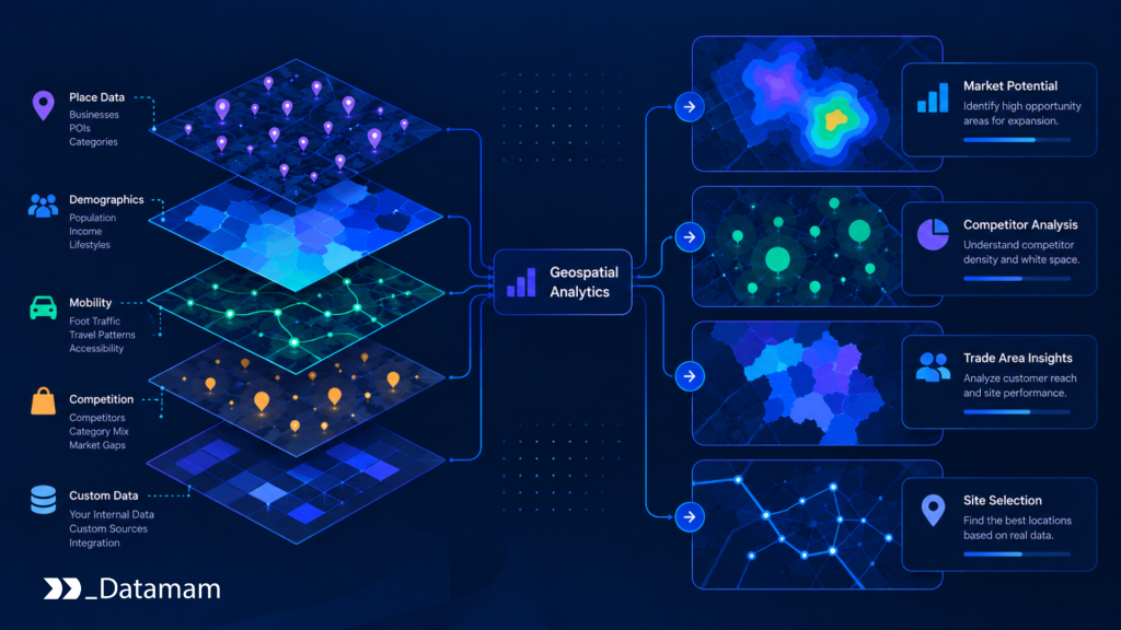
Geospatial Analytics turns location data into market decisions by connecting places, customers, competitors, territories, and demand patterns through spatial relationships. A list of coordinates can show where things are. Geospatial analytics explains what those locations mean for expansion, coverage, saturation, accessibility, cannibalization, and market opportunity.
Geospatial Analytics refers to the use of geographic data, place records, spatial models, and location-based analysis to understand markets and support business decisions. It includes spatial analytics, geospatial business intelligence, geographic data analysis, POI data, address validation, geocoding, competitor density, trade areas, catchment zones, drive-time analysis, white-space analysis, and location intelligence infrastructure.
Geospatial Analytics Converts Location Records Into Commercial Market Context
Location data becomes valuable when it explains commercial relationships. A store location matters because of surrounding demand, nearby competitors, travel time, visibility, access, complementary businesses, and local market structure. A warehouse matters because of delivery coverage and route efficiency. A clinic matters because of patient access and provider density. A restaurant matters because of foot traffic, competition, parking, and neighborhood behavior.
McKinsey’s work on geospatial analytics in retail describes retail networks as complex systems rather than isolated store points. That framing is important because geospatial analytics helps teams see how locations interact with one another, customers, channels, competitors, and local environments.
Spatial Analytics Helps Enterprises Understand Proximity, Density, Coverage, Accessibility, and Market Overlap
Spatial analytics helps enterprises measure relationships that ordinary spreadsheets cannot explain well. Proximity shows what is nearby. Density shows concentration. Coverage shows which markets are served. Accessibility shows how easily customers can reach a location. Market overlap shows where locations compete with each other.
These concepts matter for real decisions. A retailer may need to know whether a new store will expand reach or cannibalize an existing location. A franchise brand may need to know which territories are underserved. A logistics team may need to know where service coverage is weak. A healthcare network may need to know where patients lack access to nearby facilities.
In practice, spatial analytics turns location data into operational and strategic questions.
Geospatial Business Intelligence Connects Place Data With Revenue, Customers, Competitors, Territories, and Demand Signals
Geospatial business intelligence becomes stronger when place data is connected with business performance. A location point alone is limited. A location point connected to revenue, foot traffic, customer density, competitor proximity, trade area demographics, store format, category, and market demand becomes decision-ready.
For example, two stores may have similar sales but very different opportunity profiles. One may operate in a saturated market with high competitor density. Another may operate in an underserved market with weak visibility and low local awareness. Internal performance alone does not explain that difference. Spatial context does.
Therefore, geospatial business intelligence should combine POI data, internal performance data, customer geography, competitor locations, territory boundaries, and market demand indicators.
Why Location Data Alone Does Not Create Market Insight
Location data alone does not create market insight because coordinates do not explain business meaning. A coordinate may represent a store, a closed branch, a duplicate business, a building centroid, a shopping center, a franchise unit, or an outdated listing. Without context, the map may look precise while the analysis remains weak.
Deloitte’s analysis of geospatial analytics use cases notes that geospatial data is increasingly used across sectors as location-aware technologies, connected devices, and digital mapping capabilities expand. However, the decision value comes from combining location signals with analytical context, not simply from collecting coordinates.
Geographic Data Analysis Fails When Coordinates Are Not Connected to Business Identity, Category, Status, and Market Context
Geographic data analysis depends on business identity. A company needs to know whether multiple records describe the same place, whether a business is open or closed, whether it belongs to a chain, whether it is categorized correctly, and whether the coordinates are accurate enough for the use case.
A restaurant mapped to the wrong side of a highway can distort accessibility analysis. A closed retailer counted as active can inflate competitor density. A duplicate franchise unit can make a territory look more saturated than it is. A misclassified clinic can distort healthcare access analysis.
As a result, location intelligence requires verified place data before spatial models are trusted. The importance of reliable place data cannot be overstated in effective decision-making. Accurate geographic information ensures businesses can target the correct demographics and improve their service delivery. Without trustworthy data, companies risk misallocating resources and missing strategic opportunities.
Raw Maps Can Mislead Teams When Places Are Duplicated, Misclassified, Poorly Geocoded, or Outdated
Raw maps can create false confidence. Visual outputs often look authoritative, but the underlying data may contain stale records, duplicate locations, wrong categories, low-confidence geocodes, missing business status, or incomplete source history.
These errors directly affect decisions. White-space analysis may identify false opportunities. Trade area analysis may underestimate competition. Territory planning may create inefficient coverage. Site selection may overstate demand. Competitive mapping may miss important nearby locations.
Therefore, geospatial analytics requires quality controls before visualization. A clean map is not enough. The place data behind the map must be accurate, current, and traceable.
The Strategic Value of Spatial Market Interpretation
The strategic value of geospatial analytics is its ability to interpret markets spatially. Markets are not only segments or revenue pools. They are physical and behavioral systems shaped by access, distance, density, mobility, competition, and local demand.
Esri’s overview of location intelligence describes location analysis as a way for organizations to gain insight from place-based relationships across use cases such as retail site selection, asset management, supply chains, and infrastructure. This aligns with how enterprises use spatial analytics: not just to map locations, but to decide where to act. Point of interest data analysis tools allow businesses to glean actionable insights from spatial data. By utilizing these tools, companies can enhance their understanding of customer behaviors and preferences. This knowledge ultimately helps optimize operational efficiencies and improve decision-making strategies.
Enterprises Can Identify White Space, Saturation, Cannibalization Risk, Competitor Clusters, and Underserved Areas
Geospatial analytics helps enterprises identify different market conditions. White space shows areas with demand but limited coverage. Saturation shows markets with high competitor or internal density. Cannibalization risk shows where a new location may take demand from an existing location. Competitor clusters show where rivals are concentrating. Underserved areas show where access is weak.
These signals support expansion, consolidation, territory planning, franchise development, retail network design, healthcare access planning, restaurant growth, and commercial real estate evaluation.
A simple spatial decision model can classify market opportunity: Site selection strategies beyond demographics are essential for understanding the nuanced needs of various markets. By incorporating factors such as consumer behavior, local competition, and transportation access, businesses can create a more comprehensive approach to identifying prime locations. This multifaceted analysis not only enhances decision-making but also optimizes resource allocation for sustained growth.
def classify_market_area(area):

    if area["demand_score"] >= 80 and area["competitor_density"] == "low":

        return {"market_signal": "white_space", "action": "evaluate_expansion"}


    if area["internal_store_overlap"] == "high":

        return {"market_signal": "cannibalization_risk", "action": "review_network_design"}


    if area["competitor_density"] == "high" and area["share_gap"] > 0.15:

        return {"market_signal": "competitive_pressure", "action": "review_local_strategy"}


    if area["access_score"] < 60:

        return {"market_signal": "coverage_gap", "action": "review_service_access"}


    return {"market_signal": "monitor", "action": "continue_tracking"}


area = {

    "market_id": "north-atlanta-submarket",

    "demand_score": 86,

    "competitor_density": "low",

    "internal_store_overlap": "low",

    "share_gap": 0.04,

    "access_score": 78,

}


classify_market_area(area)
This kind of logic shows how spatial data becomes a decision signal rather than a map layer.
Market Decisions Improve When Location Data Is Analyzed Across Trade Areas, Catchment Zones, Drive Times, and Local Demand Patterns
Market decisions improve when location data is analyzed through trade areas, catchment zones, drive times, walk times, transit access, and local demand patterns. These methods help teams understand how people interact with places rather than simply how far apart locations are.
A five-mile radius may be meaningless if traffic patterns, highways, rivers, transit routes, or neighborhood boundaries affect access. A ten-minute drive time may be more useful than a static radius. A catchment zone may show where customers actually come from. A trade area may show which competitors influence the same demand pool.
Accordingly, spatial models should reflect real market behavior, not only geometric distance.
How Geospatial Analytics Supports Enterprise Decision-Making
Geospatial analytics supports enterprise decision-making by helping teams evaluate where to expand, where to consolidate, where to invest, where competition is rising, and where demand is underserved. It creates a shared spatial view across strategy, finance, operations, marketing, real estate, and analytics teams.
Deloitte’s 2025 Retail Industry Outlook highlights continued retail pressure around consumers, margins, stores, technology, and operating models. In that environment, spatial analysis helps retailers and other location-dependent businesses understand which local markets deserve capital, marketing, staffing, or network attention.
Retail, Restaurant, Healthcare, Real Estate, Logistics, and Franchise Teams Use Spatial Signals to Evaluate Market Opportunity
Different industries use spatial signals differently. Retailers evaluate store networks, competitor density, trade areas, and category demand. Restaurants evaluate foot traffic, nearby concepts, delivery zones, parking, and neighborhood patterns. Healthcare organizations evaluate patient access, provider density, and service gaps. Real estate teams evaluate tenant mix, location quality, and surrounding demand. Logistics teams evaluate service coverage, route efficiency, and facility placement. Franchise teams evaluate white space and territory conflicts.
The common principle is the same: market opportunity is spatial. Better geographic data analysis helps organizations understand where opportunity exists and where risk is concentrated.
Competitor Density, Store Networks, POI Categories, Foot Traffic, Demographics, and Internal Performance Data Create Stronger Market Models
Strong market models combine multiple layers. Competitor density shows competitive pressure. Store network data shows internal coverage. POI categories show commercial context. Foot traffic can indicate location activity. Demographics provide population and household context. Internal performance data shows business outcomes. Geographic boundaries, drive times, and catchment zones connect these layers spatially.
No single layer explains the market alone. A high-income area may still be unattractive if competition is dense and access is poor. A low-density area may be attractive if demand is underserved and competitor presence is weak. A strong location may underperform if its trade area overlaps heavily with another internal location.
Geospatial analytics helps teams interpret these combinations.
The Infrastructure Layer Behind Scalable Geospatial Analytics
Scalable geospatial analytics requires data infrastructure. POI collection, address validation, geocoding, deduplication, category mapping, enrichment, QA, refresh pipelines, and spatial data delivery must work together. Without infrastructure, spatial analysis becomes manual, inconsistent, and difficult to trust.
Browser automation frameworks such as Playwright can collect public location and business information from store locators, directories, maps, and business websites. Airflow can orchestrate recurring refresh workflows. Spark can process large POI and geospatial datasets. dbt can standardize transformation logic. Snowflake, BigQuery, and Databricks can store and analyze spatial and business data. Great Expectations can validate quality rules. Prometheus and data observability systems can monitor freshness and pipeline reliability. GIS systems and geocoding APIs support spatial processing and map-based analysis.
POI Collection, Address Validation, Geocoding, Deduplication, Category Mapping, and Refresh Pipelines Make Spatial Data Decision-Ready
POI collection captures business names, addresses, coordinates, categories, hours, websites, contact details, source URLs, and operating status. Address validation standardizes location text. Geocoding turns addresses into coordinates. Deduplication removes repeated records. Category mapping aligns places to business taxonomy. Refresh pipelines detect openings, closures, relocations, and source changes.
A spatial readiness gate can determine whether a record is strong enough for analytics:
def evaluate_spatial_record(record):

    if record["geocode_confidence"] < 0.90:

        return {"status": "review", "reason": "low_geocode_confidence"}


    if record["duplicate_risk"] == "high":

        return {"status": "merge_review", "reason": "possible_duplicate"}


    if record["category_status"] != "approved":

        return {"status": "review", "reason": "category_not_approved"}


    if record["operating_status"] not in ["open", "temporarily_closed"]:

        return {"status": "exclude", "reason": "inactive_location"}


    if record["last_verified_days"] > 90:

        return {"status": "refresh", "reason": "stale_place_record"}


    return {"status": "spatial_analytics_ready", "place_id": record["place_id"]}


record = {

    "place_id": "poi_77291",

    "geocode_confidence": 0.94,

    "duplicate_risk": "low",

    "category_status": "approved",

    "operating_status": "open",

    "last_verified_days": 21,

}


evaluate_spatial_record(record)
This protects spatial models from using weak, stale, or misleading place records.
Airflow, Spark, dbt, Snowflake, BigQuery, Databricks, Great Expectations, Prometheus, GIS Systems, and Geocoding APIs Support Scalable Geographic Data Analysis
Each infrastructure component supports a specific function. Airflow manages schedules and dependencies. Spark processes large datasets. dbt standardizes transformations. Snowflake, BigQuery, and Databricks support analytical storage and compute. Great Expectations validates quality. Prometheus monitors operational reliability. GIS systems support trade areas, isochrones, overlays, and spatial joins. Geocoding APIs convert addresses into coordinates.
However, tools do not create insight automatically. They need accurate place data, quality thresholds, source traceability, metadata, governance, and business context. Otherwise, the organization may scale maps faster than it scales decision reliability.
Why Geospatial Analytics Is Becoming an Executive Intelligence Issue
Geospatial Analytics is becoming an executive intelligence issue because capital allocation, market expansion, competitive strategy, territory design, and network optimization all depend on spatial evidence. Leaders need to know where growth is possible, where markets are overbuilt, where competitors are concentrating, and where customer access is weak.
Executives do not need to manage geocoding logic or POI matching rules. However, they need confidence that spatial models are built on reliable data and that location decisions are not being made from outdated or incomplete market representations.
Leaders Need Visibility Into Where Markets Are Growing, Where Competition Is Concentrated, and Where Expansion Risk Is Rising
Leadership visibility should focus on spatial risk and opportunity. Which markets show white-space potential? Which territories are saturated? Also, which stores are at risk of cannibalization? Which competitors are expanding nearby? Which regions have weak service coverage? Also, which trade areas have strong demand but limited access? Which location investments require deeper review?
These questions connect directly to revenue, margin, capital planning, operating efficiency, and competitive position. Geospatial business intelligence gives leaders a clearer view of where action is needed.
Scalable Geospatial Analytics Requires Reliable Place Data, Source Traceability, Spatial Governance, Quality Controls, and Continuous Market Review
Scalable geospatial analytics requires reliable place data. It also requires source traceability, spatial governance, refresh cadence, quality controls, and continuous market review. Place records change. Competitors open and close locations. Categories shift. Addresses are corrected. New developments change accessibility. Market boundaries evolve.
Ultimately, Geospatial Analytics turns location data into market decisions when it connects accurate place records with business context. Spatial analytics helps enterprises understand proximity, density, coverage, accessibility, and market overlap. Geospatial business intelligence connects locations with revenue, customers, competitors, territories, and demand signals. Geographic data analysis becomes valuable when it moves beyond mapping and starts explaining where opportunity, risk, and competitive pressure actually exist.